Beginning with Habitat
Advancing Conservation in Maine’s Most Important Landscapes
Editor’s Note: With 17 million acres of forest and over 3,000 miles of tidal coastline, Maine is home to some of New England’s most diverse ecosystems. With such abundance, prioritizing what conservation efforts are advanced and where they happen first becomes an important and daunting challenge. In this essay, Justin Schlawin introduces how the team at Beginning with Habitat has addressed the task by offering consistent, useful, and timely support to diverse stakeholders across the landscape. – Alex Redfield
In 2011, Bethany Atkins was still on maternity leave when she brought her newborn son, Ben, to a conservation planning meeting with the Kennebec Estuary Land Trust. As a conservation planner with the Maine Department of Inland Fisheries and Wildlife’s Beginning with Habitat (BwH) program, Bethany had been working alongside state and nonprofit conservation partners to designate the Kennebec Estuary as a Focus Area of Statewide Ecological Significance. Containing a globally important freshwater tidal delta; more than 20 percent of Maine’s tidal marshes; extensive sandy beach and dune habitats; two dozen rare plant species; and 12 threatened, endangered, and special concern wildlife species, the Kennebec Estuary has long been a key focus for conservation. This meeting with the Kennebec Estuary Land Trust was pivotal in planning for the future of this important ecological landscape and could not be missed.
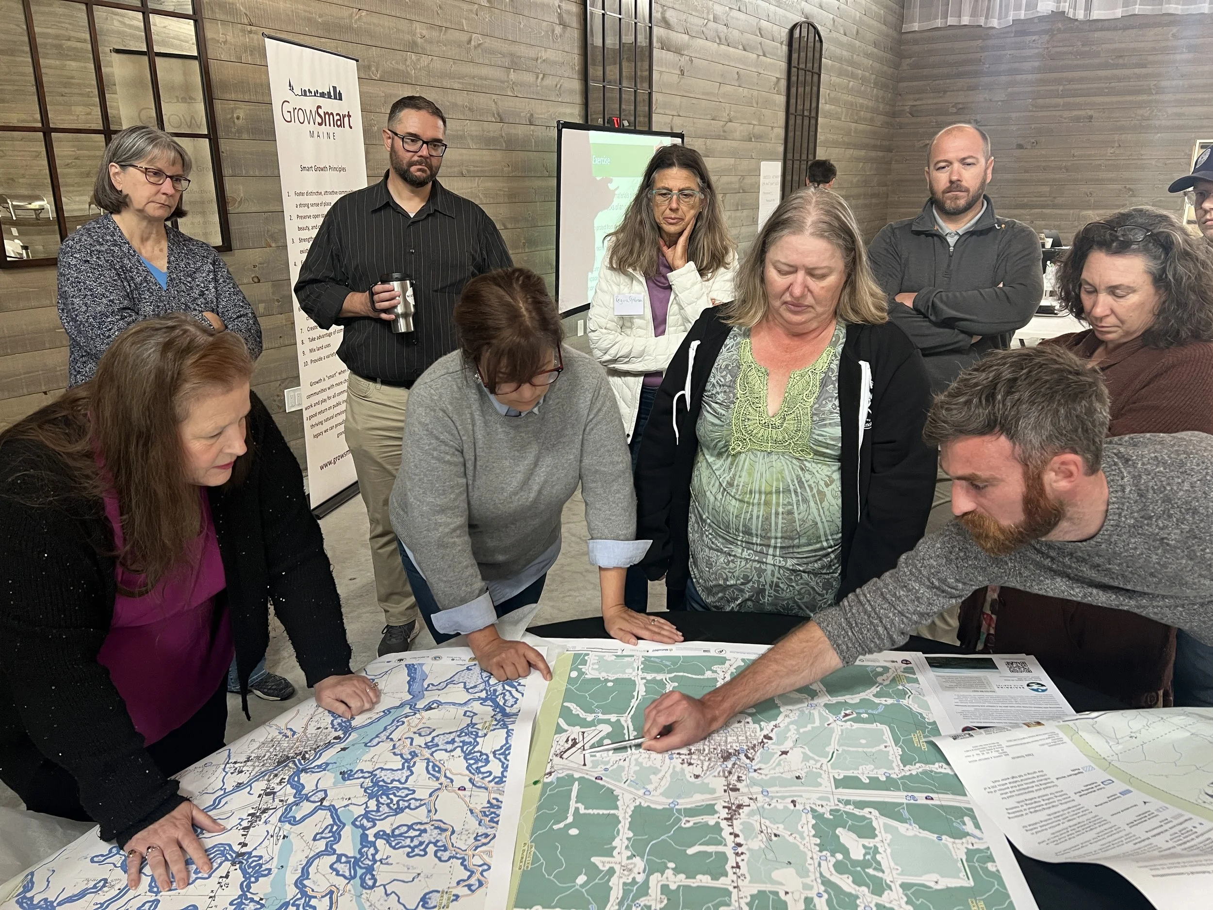
The Beginning with Habitat Program works with private landowners, municipalities, and conservation partners to incorporate habitat needs in long-term plans. Beginning with Habitat provides thematic maps, map viewers, and technical assistance for natural resource planning and conservation. Photo courtesy of Dayea Shim, GrowSmart Maine
For more than 25 years, BwH staff have worked to accelerate habitat conservation and restoration in Maine’s most important ecological landscapes. BwH provides in-person technical assistance to landowners, convenes conservation partners working toward common goals, assists municipalities with comprehensive planning and technical expertise, and provides partners with detailed maps of critical and important natural resources.
In the mid-2000s, BwH recognized the need to identify priority landscapes to guide future work, and accordingly began a collaborative process to identify and map Focus Areas of Statewide Ecological Significance. With partners at The Nature Conservancy, Maine Audubon, the Maine Natural Areas Program, Maine Coast Heritage Trust, and the United States Fish and Wildlife Service, BwH developed metrics for identifying the areas in highest need of conservation and stewardship. Criteria for designation included the presence of rare and endangered species, high-value ecosystems, Significant Wildlife Habitats, and large areas of unfragmented land. These Focus Areas inform where and how state agencies provide direct technical assistance and planning support, but they also serve to motivate municipal or nonprofit conservation measures. Additionally, Focus Area designations are used to evaluate applications for Land for Maine’s Future funding and other grant programs, and municipalities are required to consider Focus Areas in their comprehensive planning process. The Kennebec Estuary was one of the first Focus Areas identified by BwH.
With her infant son sleeping in a baby carrier, Bethany spread out large maps of the Kennebec Estuary service area, overlaid with Mylar film. “I found myself hand-drawing areas of undeveloped habitat on the maps,” Bethany recalls. “Committee members were encouraged to draw areas of importance [and places] where the land trust could support ecosystem and community conservation in the Kennebec Estuary Focus Area.”
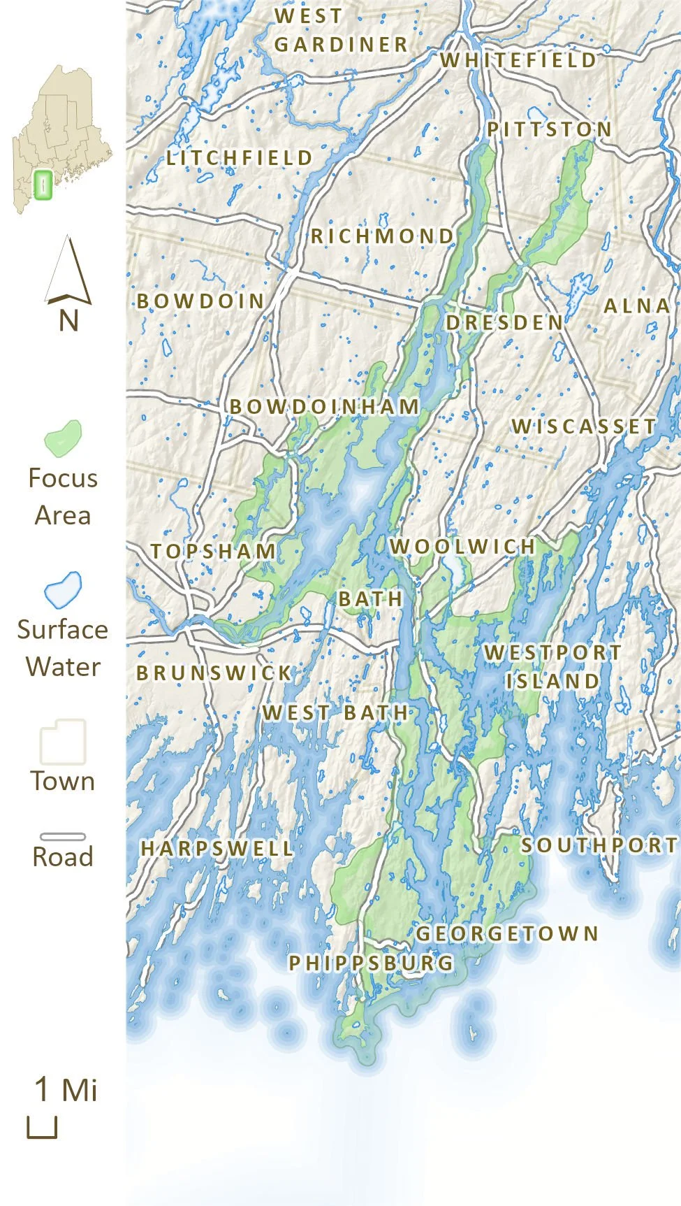
The Kennebec Estuary Focus Area of Statewide Ecological Significance includes a range of intertidal habitats of statewide importance, including beaches, dunes, mudflats, salt marshes, and freshwater tidal marshes. Image courtesy of the Maine Dept. of Inland Fisheries and Wildlife
Ultimately, these community-generated maps were digitized and combined with data on rare species, undeveloped habitat blocks, and projected impacts of sea level rise. These maps served as the backbone for a broader strategic plan for the land trust’s entire service area. Since the development of this plan in 2011, approximately 3,500 acres in the Focus Area have been conserved through both easement and fee acquisition. These conservation efforts have protected coastal shoreline, marsh migration areas, islands, wetlands, and large tracts of upland forest, while also supporting several significant tidal marsh restoration projects. The State of Maine, land trusts, and neighboring municipalities all played a role in these conservation efforts.
Beyond its collaboration with the Kennebec Estuary Land Trust, BwH has been actively working in the Focus Area to support volunteer committees and municipal staff in developing comprehensive plans, and to build effective relationships with private landowners. BwH conservation biologists have engaged all 14 municipalities within the Focus Area over the last decade, providing technical assistance through presentations and map production, analyzing and sharing relevant conservation data, and assisting with development of municipal ordinance review. Additionally, private lands biologists with BwH have conducted field visits and forest management plan reviews that shape the management of approximately 5,000 acres of habitat. This multi-pronged approach—engaging land trusts, private landowners, and municipalities while prioritizing efforts within Focus Areas like the Kennebec Estuary—is emblematic of BwH’s work statewide.
To ensure this work remains effective over time, Focus Areas and other conservation priorities must be revisited and updated with new science and inventory data. In 2023, BwH partners completed a needed update to the map of Focus Areas using objective metrics and robust GIS analysis. The updated map now includes a total of 141 Focus Areas across the state. Though Focus Areas account for only about 11.5 percent of Maine’s land base, collectively they include examples of more than 85 percent of Maine’s rare, threatened, and endangered plant and animal species, and high-quality examples of Maine’s most sensitive ecosystems.
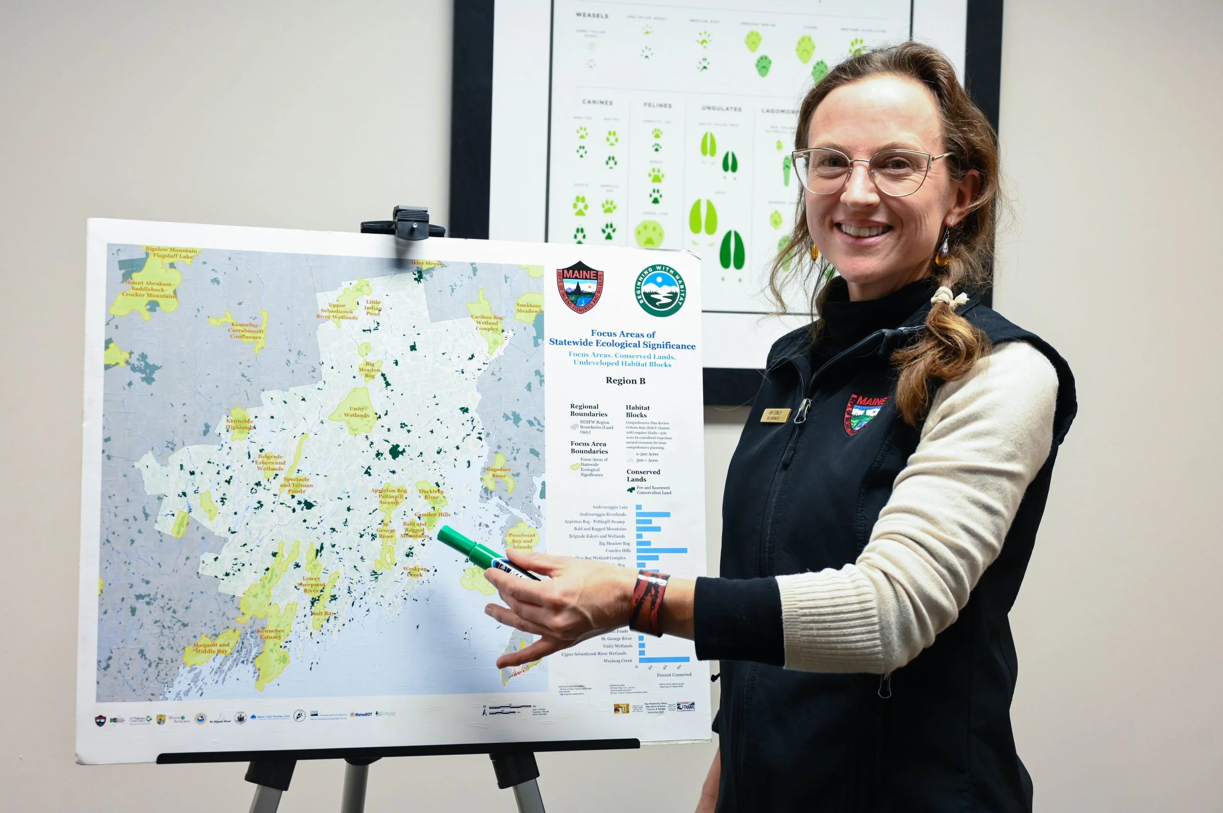
Amy Dowley, the GIS Coordinator for Beginning with Habitat, shares a map of the Focus Areas of Statewide Ecological Significance identified in Midcoast Maine. To explore the extent of the state’s designated priority landscapes, visit the Beginning with Habitat (BwH) Map Viewer. Photo courtesy of the Maine Dept. of Inland Fisheries and Wildlife
During this 2023 update, the need for additional landscape conservation planning tools was identified. While the Focus Areas include biodiversity hotspots, these places could become isolated if not connected to each other by intact habitat. Additionally, the Focus Areas did not include priority areas for restoration or habitat management, or areas of cultural or community importance. Through updates to Maine’s Climate Action Plan,State Wildlife Action Plan, and Maine Coastal Program Strategic Outlook, BwH partners identified a need to broaden habitat and community conservation targets not well captured in the mapping of Focus Areas. As a result, in 2025 BwH began a collaborative process to develop a landscape conservation blueprint to guide future conservation and management of key places and ecosystems. Additional habitat conservation targets to be identified through the conservation blueprint include aquatic networks that benefit from habitat protection or restoration, wildlife road crossings, and areas identified as climate refugia, among others. This effort will continue through 2027 and is intended to provide a collaborative vision for maintaining and restoring a resilient and connected landscape for people and wildlife.
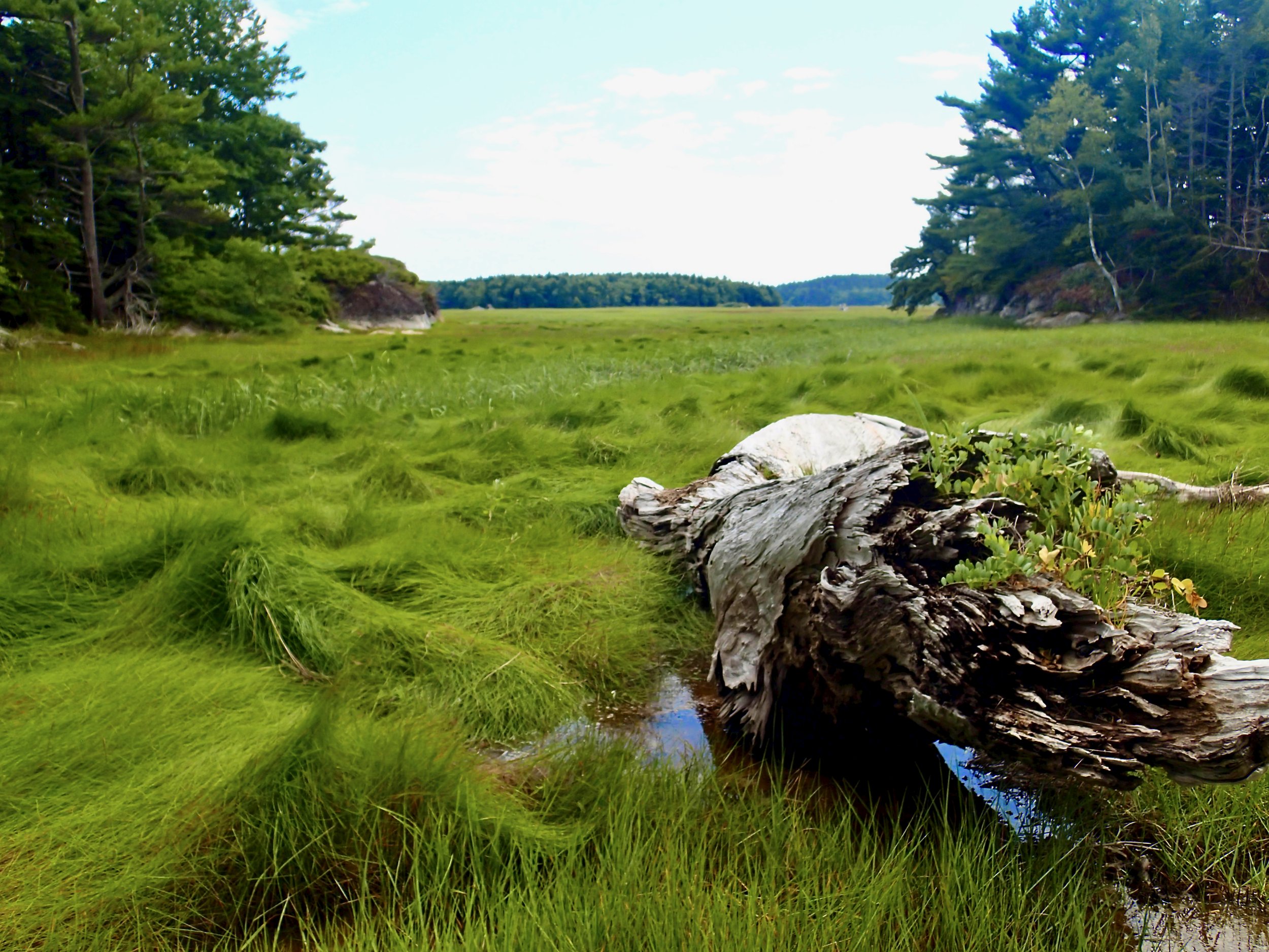
A salt marsh within Popham Beach State Park, Phippsburg, Maine. Photo courtesy of the Maine Dept. of Inland Fisheries and Wildlife
The BwH program actively continues its work in the Kennebec Estuary Focus Area. More recent work includes a public-private collaboration on tidal marsh restoration in the Popham Peninsula, sharing resources and information to assist with community climate resilience plans, and support for municipal open space plans that identify conservation opportunities in the broader context of land use needs. Building on its early days of tracing habitat on Mylar maps, BwH continues to bring people together to shape the future of Maine’s most important landscapes.
Justin Schlawin coordinates and directs Beginning with Habitat, a program of the Maine Department of Inland Fisheries and Wildlife. Justin supervises staff; promotes collaboration with steering committee members and partners; advances landscape-scale initiatives; and facilitates the delivery of technical assistance on habitat conservation and management to municipalities, conservation partners, and private landowners. Justin lives with his family in Bowdoinham, Maine.